A “MONSTER” hurricane has swelled into the first Category 5 storm of the year, unleashing 160mph winds as it barrels toward a tourist hotspot loved by Americans.
Genevieve reached the highest level on the hurricane scale after rapidly strengthening over the Pacific, while its massive swells threaten swimmers and small boats.
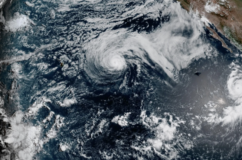
The powerhouse storm was churning off Mexico’s Baja California Peninsula, home to popular vacation destinations including Cabo San Lucas.
But despite moving in the peninsula’s general direction, Genevieve is not expected to strike Mexico and should remain far offshore as it tracks northwest.
The hurricane has already eased slightly to Category 4 strength, with winds falling to 155mph, and forecasters expect it to weaken steadily through the rest of the week.
But dangerous waves generated by the hurricane are set to reach Mexico’s west coast and spread toward California.
Forecasters warned the huge swells could produce rough surf and powerful rip currents along beaches despite Genevieve staying out at sea.
The swells are also expected to spread north and produce hazardous beach conditions along parts of California.
Small boats and swimmers could face powerful waves and dangerous currents despite Genevieve’s center remaining hundreds of miles offshore, AccuWeather reported.
Genevieve became the first Category 5 hurricane in the eastern Pacific since Kristy reached the same strength in 2024.
AccuWeather hurricane expert Alex DaSilva called it the most powerful storm in the waters surrounding North and Central America so far this year.
“While eastern Pacific Major Hurricane Genevieve poses no direct threat to land, it has become the most powerful hurricane in the waters surrounding North and Central America this year and the first Category 5 hurricane since Kristy in 2024,” he said.
Genevieve is expected to continue northwest before turning more toward the west-northwest through the middle of the week.
Cooler water and drier air should then begin draining its strength, with faster weakening forecast later in the week.
The system could fall back to tropical-storm strength by the weekend as it moves farther over the open Pacific.
Meanwhile, Hurricane Fausto is slicing west-northwest toward Hawaii but is forecast to pass north of the islands.
The Category 1 storm was about 580 miles east of Hilo on Monday, packing sustained winds of 80mph and moving at 14mph.
Residents have been urged to monitor its progress, although no coastal watches or warnings were issued.
Fausto is expected to weaken steadily while approaching the islands and should pass by as a tropical storm.
Increasing wind shear is forecast to rip apart its structure before it becomes a remnant low later this week.
Most of Fausto’s wind and rain should remain north of Hawaii, but moisture trailing from the system could trigger scattered showers and gusty thunderstorms.
“That’s about the only way parts of Hawaii may get any rain from Fausto,” DaSilva said.
“But, any problems from flash flooding would be extremely isolated.”
The greater threat will be in the water, with large breakers, rough surf and rip currents expected along north- and east-facing shores.
Powerful swells and strong currents were already increasing along Hawaii’s eastern coastline on Monday.
Source: https://www.the-sun.com/news/16755894/hurricane-genevieve-category-5-storm-barrels-baja-california/